
Longitude lines and time
The Prime Meridian divides the world effectively into an eastern hemisphere and a western hemisphere.

Looking at the map above, identify the Prime Meridian (in the centre), and how moving west (left) we have North and South America, Greenland, a spattering of African countries like Mauritania and Morocco and a few European countries like Portugal, the UK and Iceland. The rest of the world is pretty much in the east. Where the eastern hemisphere meets the western hemisphere on the opposite side of the world, (not the Prime Meridian), this is called the International Date Line (IDL).
The International Date Line, is a special meridian. The western side is always $24$24 hours ahead of the eastern side of the line. It passes through the middle of the Pacific Ocean at about $180°$180° line of longitude but it has been drawn around some territories and island groups, so that the date change won't happen through the middle of a town.
Why would the International Date Line (IDL) be a crooked line instead of a straight line? What would happen if the IDL was straight?
The world is spinning on its axis as it rotates around the sun. Each full spin on its axis is $24$24 hrs ($1$1 day). We often focus on $24$24 lines of longitude, all spaced $15$15° apart, making a full $360$360° rotation. This means that roughly speaking, it takes $1$1 hour for the earth to spin $15$15° on its axis.
$15^\circ$15° of longitude = $1$1 hour
$1^\circ$1°of longitude = $4$4 minutes
If we move EAST, then the time increases, travelling WEST and the time decreases (remember that New Zealand is the first country to celebrate the new year every year because it is the furthest east).
Practice questions
Question 1
The Earth turns $360^\circ$360° in $24$24 hours.
How many degrees does it turn in $1$1 hour?
For every $75^\circ$75° of longitude, what is the time difference (in hours)?
For every $1^\circ$1° of longitude, what is the time difference (in minutes)?
Question 2
Calculate the time difference between Hong Kong ($22$22°$N$N, $114$114°$E$E) and Beirut ($34$34°$N$N, $36$36°$E$E) to the nearest hour.
Time zones
The world has $24$24 standard time zones, from $-11$−11 to $+12$+12, plus non-standard time zones, including $+13$+13 and $+14$+14, as well as about $15$15 different half-hour and $45$45-minute offset time zones. A time zone is a region of the Earth that has adopted the same standard time, and those regions are roughly divided up by the lines of longitude. These time zones are based on Greenwich Mean Time (GMT) or Coordinated Universal Time (UTC).
In the following map, the colour of the region is used to indicate the time zone.
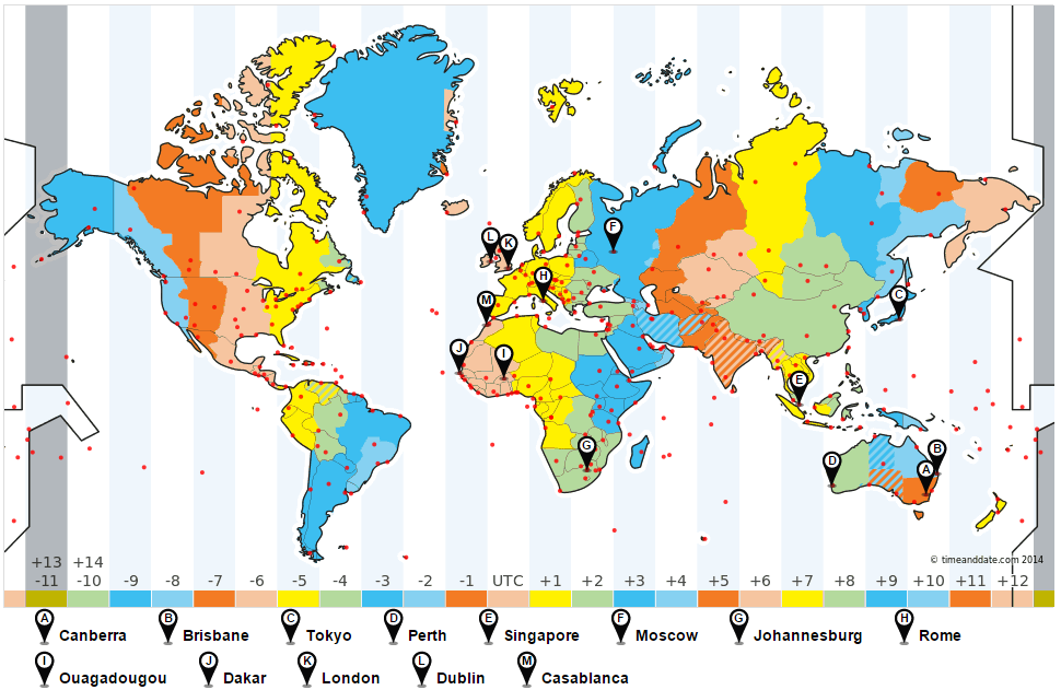
If you look at the coloured bar along the bottom of the map, you will see how the time zones should be broken up, according to the lines of longitude. If you compare this to the colours of the map, you will notice that the countries that follow that time zone aren't always perfectly within that zone. There are various reasons for this:
- some countries want to stay in sync with their neighbours' time zones, like many of the countries in western Europe
- many larger countries, like the USA, break themselves into multiple time zones, so that everyone experiences a similar day
- some countries, even though they are wide and cross many time zones, choose to stay with the same time zone, like China
- some countries and states, like India and Nepal, and South Australia and the Northern Territory, use half hourly or quarter hourly time zones, which are indicated with stripes
Greenwich Mean Time (GMT) and Coordinated Universal Time (UTC)
Greenwich Mean Time (GMT) is a time zone based upon the Prime Meridian, which goes through the Royal Observatory in Greenwich, England. Coordinated Universal Time (UTC), is a time standard, or a system of time-keeping, and is often used interchangeably, as the actual times are the same.
All other time zones are based on how far they are behind or ahead of GMT/UTC. The zone of Greenwich Mean Time is considered to be $0$0. Countries to the west of the Prime Meridian are behind GMT and use a negative ($-$−) GMT/UTC. Countries to the east of the Prime Meridian are ahead of GMT and use a positive ($+$+) GMT/UTC.
For example, Argentina and Paraguay are $-3$−3 GMT, which means these countries are $3$3 hours behind Greenwich Mean time, so if was midday in England, it would be $9$9 am in Paraguay. Western Australia is $+8$+8 GMT, which means it is $8$8hours ahead of GMT. If it was midday in England it would be $8$8 pm in WA.
If we move WEST, then the time decreases, and has a negative ($-$−) GMT/UTC.
If we move EAST, then the time increases, and has a positive ($+$+) GMT/UTC.
Calculating time differences
Using maps like the one above, tables like the one below, or websites like www.timeanddate.com, we can calculate the time difference between two cities or counties
| GMT offset | Location |
|---|---|
| $-5$−5 | New York, Cuba, Peru |
| $-4$−4 | Chile, Barbados, Brazil (west), Bolivia |
| $-3$−3 | Argentina, Brazil (east), Uruguay, Greenland |
| $-2$−2 | south Sandwich Islands |
| $-1$−1 | Azores |
| $0$0 | UK, Ireland, Iceland, Portugal, Ghana, Liberia, Mali |
| $+1$+1 | Algeria, Angola, Chad, Bosnia, Croatia |
| $+2$+2 | Finland, Greece, Lebanon, Egypt, south Africa |
| $+3$+3 | Russia (west), Saudi Arabia, Kenya, Madagascar, Iraq |
| $+3.5$+3.5 | Iran |
| $+4$+4 | Mauritius, United Arab Emirates, Armenia |
| $+4.5$+4.5 | Afghanistan |
| $+5$+5 | Pakistan, Maldives, Kazakhstan |
| $+5.5$+5.5 | India, Sri Lanka |
From the map above, we can see that Johannesburg is behind Tokyo. Johannesburg is $+2$+2 GMT, and Tokyo is $+9$+9 GMT, which means the difference is $+9-+2=7$+9−+2=7 hours. This means Johannesburg is $7$7 hours behind Tokyo, or alternatively, Tokyo is $7$7 hours ahead of Johannesburg.
From the table, Chile is $-4$−4 GMT and Iran is $+3.5$+3.5. The difference is $+3.5--4=7.5$+3.5−−4=7.5 hours. As $+3.5>-4$+3.5>−4, this means that Iran is ahead of Chile. We can then say that Iran is $7.5$7.5 hours ahead of Chile, or alternatively, Chile is $7.5$7.5 hours behind Iran.
Practice questions
Question 3
In the following map, the colour of the region is used to indicate the time zone.

What is the time difference between Moscow and Dublin?
question 4
Maria wants to know the time in Bangkok (UTC $+7$+7) when it is $11$11am in Athens (UTC $+2$+2).
Calculate the time difference between the two cities. Hence find the time in Bangkok when it is $11$11am in Athens. $\editable{}$ pm
Question 5
The following table shows the time of several locations relative to UTC.
| UTC offset | Location |
|---|---|
| $-5$−5 | New York, Cuba, Peru |
| $-4$−4 | Chile, Barbados, Brazil (west), Bolivia |
| $-3$−3 | Argentina, Brazil (east), Uruguay, Greenland |
| $-2$−2 | South Sandwich Islands |
| $-1$−1 | Azores |
| $0$0 | UK, Ireland, Iceland, Portugal, Ghana, Liberia, Mali |
| $+1$+1 | Algeria, Angola, Chad, Bosnia, Croatia |
| $+2$+2 | Finland, Greece, Lebanon, Egypt, South Africa |
| $+3$+3 | Russia (west), Saudi Arabia, Kenya, Madagascar, Iraq |
| $+3.5$+3.5 | Iran |
| $+4$+4 | Mauritius, United Arab Emirates, Armenia |
| $+4.5$+4.5 | Afghanistan |
| $+5$+5 | Pakistan, Maldives, Kazakhstan |
| $+5.5$+5.5 | India, Sri Lanka |
What is the time difference between Kenya and Mauritius?
When it is $1$1$7$7:$2$2$5$5 on the $15$15th day of the month in Kenya, what time is it in Mauritius? Give your answer in 24 hour time.
$\editable{}$$\editable{}$:$\editable{}$$\editable{}$
Applications of world time zones
There are many possibly applications, and one main area is communication. For example, when making phone calls (or video calls) with people in other countries, whether it be for business, or calling family and friends, we need to ensure we are calling at appropriate times.
We can use the GMT of the two people involved, or even just the time difference, for scheduling calls. Another way is to use a website, like www.timeanddate.com, which provides various tools for scheduling your time.
One way of doing this is by using the "Current Time" of cities around the world. The table below is an excerpt of the list they might provide:
| City | Current Time |
|---|---|
| Madrid | Fri $2:52$2:52 am |
| Managua | Thu $6:52$6:52 pm |
| Manila | Fri $8:52$8:52 am |
| Melbourne | Fri $10:52$10:52 am |
| Mexico City | Thu $7:52$7:52 pm |
| Miami | Thu $8:52$8:52 pm |
| Minneapolis | Thu $7:52$7:52 pm |
| Minsk | Fri $3:52$3:52 am |
| Montevideo | Thu $9:52$9:52 pm |
| Montreal | Thu $8:52$8:52 pm |
| Moscow | Fri $4:52$4:52 am |
| Mumbai | Fri $6:22$6:22 am |
From the table above we can see that the current time in Minsk is Fri $3:52$3:52 am, and the current time in Montevideo is Thu $9:52$9:52 pm. As it is currently Thursday in Montevideo, and it is currently Friday in Minsk, we can see that Minsk is ahead of Montevideo. More specifically, Minsk is $6$6 hours ahead of Montevideo.
Practice questions
Question 6
Valerie in Hobart has a phone conversation with Oprah in Manilla. Manilla is $2$2 hours behind Hobart time.
If Valerie calls at $10$10:$30$30am, what time is it for Oprah?
$\editable{}$:$\editable{}$am
If Oprah calls at $7$7:$30$30pm, what time is it for Valerie?
$\editable{}$:$\editable{}$pm
Question 7
The rugby World Cup final is broadcast live across the world. One particular year it was held in Wales and the game started at $4$4 pm local time. Where Beth lives, it is $17$17 hours behind Wales. At what time did the game start in her local time?
$\editable{}$pm
Question 8
The table shows the current time in major capital cities beginning with the letter $M$M.
| Madrid | Mon $2$2:$16$16 am |
|---|---|
| Managua | Sun $6$6:$16$16 pm |
| Manila | Mon $8$8:$16$16 am |
| Melbourne | Mon $10$10:$16$16 am |
| Mexico City | Sun $7$7:$16$16 pm |
| Miami | Sun $8$8:$16$16 pm |
| Minneapolis | Sun $7$7:$16$16 pm |
| Minsk | Mon $3$3:$16$16 am |
| Montevideo | Sun $9$9:$16$16 pm |
| Montreal | Sun $8$8:$16$16 pm |
| Moscow | Mon $4$4:$16$16 am |
| Mumbai | Mon $5$5:$46$46 am |
When it is $15$15:$10$10 Minsk time, what is the time in Madrid? Give your answer in $24$24 hour time.
$\editable{}$$\editable{}$:$\editable{}$$\editable{}$
Calculating travel times between cities
When we're calculating how long a flight takes, we need to consider the local time in both cities. Similarly, if we want to know the local time in the departure/arrival city, we need to consider the time in one city and the flight time and then adjust the time based on time zones.
Practice questions
Question 9
A plane left airport A at $8$8:$30$30 pm on Tuesday and landed at airport B at $9$9:$00$00 pm (local time) on the same day.
If airport B is $19$19 hours behind airport A, how long did the trip take?
Question 10
When the time is $5$5:$23$23 pm in Honolulu, it is $10$10:$23$23 pm in Miami. You take 19 hours to travel from Honolulu to Miami.
If you leave at $4$4:$50$50 pm on Sunday:
At what time (local time) will you arrive in Miami?
$\editable{}$: $\editable{}$ pm
On what day will you arrive in Miami?
Sunday
ASaturday
BMonday
CTuesday
D
Question 11
The following table displays the departure and flight times for three Air China flights.
| Flight Number | Airport Code | Departure Time | Airport Code | Flight Time |
|---|---|---|---|---|
| CA994 |
San Francisco UTC -8 (SFO) |
$1$1:$13$13 pm |
Beijing UTC +8 (PEK) |
$12$12 hours and $31$31 mins. |
| CA927 |
Shanghai Pudong UTC +8 (PVG) |
$5$5:$56$56 pm |
Beijing UTC +8 (PEK) |
$8$8 hours and $31$31 mins. |
| CA950 |
Beijing UTC +8 (PEK) |
$7$7:$21$21 pm |
San Francisco UTC -8 (SFO) |
$14$14 hours and $37$37 mins. |
What time does CA994 arrive in Beijing local time?
$\editable{}$ : $\editable{}$ pm
What time does CA927 arrive in Beijing local time?
$\editable{}$ : $\editable{}$ am
What time does CA950 arrive in San Francisco local time?
$\editable{}$ : $\editable{}$ pm